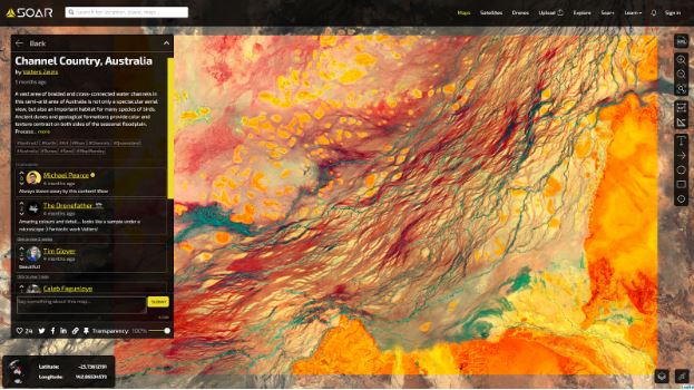
Soar.Earth is on a mission to create the largest digital atlas of the world’s maps and images. The platform allows its users to discover amazing maps, aerial and drone imagery, and daily satellite imagery from the world’s best providers. One of the best features of Soar.Earth is the ability to share your own map portfolios with users across the globe. All you have to do is upload your content on Soar.Earth and it instantly becomes shareable and also has a chance of being picked up by media outlets. The users also have access to certain annotation tools to measure and draw information over the map.
The sharing component of Soar.Earth was created to solve the problem in the mapping community of how difficult, time-consuming, and sometimes expensive it was for people to get their map and imagery content to others. Soar.Earth’s browser-based platform makes it simple, quick and easy to share map content, delivering a comfortable experience to its users.
Soar.Earth works by processing and tiling all your ECW and GeoTIFF files so they can be displayed quickly and efficiently, accurately geolocated on a basemap of the world, all inside your web browser. Once your maps are uploaded, the Soar.Earth platform makes them easily shareable at the click of a button. You can share to all of your social media channels through Soar.Earth or simply press the ‘copy link’ button to immediately generate a shareable URL. Moreover, it doesn’t require any expensive GIS software or industry know-how to operate, what more can you ask for?
Not only this, with Soar.Earth, users can also download their content and satellite imagery to use in a GIS or other imaging processing software like GlobalMapper, ERDAS, QGIS and Adobe Photoshop. Drone hobbyists, news agencies, small businesses providing services to the geospatial industry, and multinational corporations in the mining, logistics and environmental sector already use Soar.Earth to meet their daily business requirements.
Soar.Earth has a huge mapping area, enough to cover the Earth around 120 times! The platform is perfect for anyone with maps or aerial/drone imagery, who wish to reach a bigger audience with their content, interact with other users and bring value to people across the globe.
Soar.Earth has been a valuable asset in times of crisis like the bushfire damage in Australia’s Southwest and measuring the gravity of the Tonga explosion. In the face of climate change, earthquakes, and emerging volcanos, Soar.Earth comes to the rescue by providing valuable insights, near-real-time satellite imagery, and other content to users, helping them stay up-to-date and providing data they may need to take action.
Soar.Earth was founded in 2018 by Amir Farhand, an entrepreneur with a rich experience of more than 15 years in the geospatial industry. The concept for the Soar.Earth platform originated from Mappt, an Android-based, offline field-mapping application, that retains over 30,000 active users today. Soar.Earth was created after observing how users interacted with Mappt and what they needed from it.
The future ambitions of Soar.Earth involve growing their library of content, providing more features and functionality for users, and getting involved with education and humanitarian efforts as part of their passion for bringing maps and geospatial data to the world.

